Why Pay to Play?™
|
Celebrating 20
Years of RPG Freeware |
The Vintyri™ Cartographic
Collection Tutorial: Raster Mapping with Fractal
Mapper™ 8. |

Current: February 1, 2012
A Vintyri Cartographic Collection
Expansion
Updated Version 1.01 Released
February 2012
A free, open 220-page PDF booklet
with supporting files released under the Open
Game License

Click here to
skip the words and go direct to the download site!
|
This product is a
second level instruction booklet that takes up where the free NBOS manual-tutorial leaves off. The material all is presented in
step-for-step detail with more than 270 color screen shots and illustrations
intended to keep things understandable and easy. It goes from the surface of raster mapping
with FM8 into areas that usually
are viewed as being of expert level.
However, because FM8 itself
is so simple to use, even inexperienced mappers should be able to master
everything in this volume with little trouble. It should be noted
that anyone pondering whether FM8
is the right tool can work his or her way through this tutorial without
buying anything. It will work with the
free trial version of FM8 or with
the full purchase version. All other
software required for the tutorial can be downloaded free and legally in the
Internet. The first chapter
shows the cartographer how to best set up FM8
for raster mapping, explaining why these settings are made and what their
advantages are. It also explains what
other free software products might be desirable and where to download all of
them at no cost. The second chapter
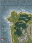
takes the reader step-by-step through the making of the overland map on the
cover of the booklet, producing it with two entirely different alternative
ocean types. A sample of this finished
map follows:
The third chapter
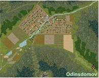
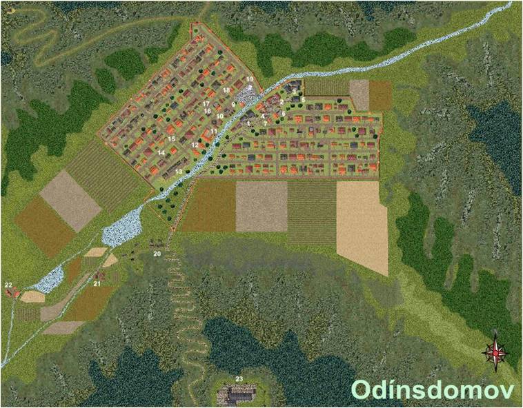
offers step-by-step instructions on how to create an FM8 "super zoom" map of a city, town or village. One makes the following map of the town of
Odínsdomov, which is a part of the free and open Jörðgarð™ campaign setting being created by the Vintyri Project. Here is an overall view of the finished
map:
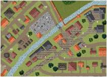
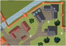
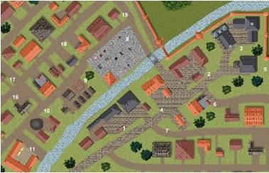
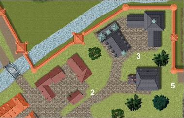
And here are two
zoom views into the town center: |
|
|
|
|
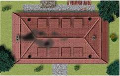
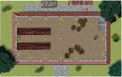
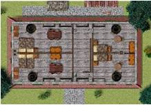
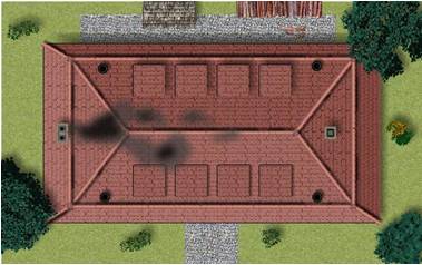
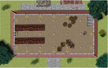
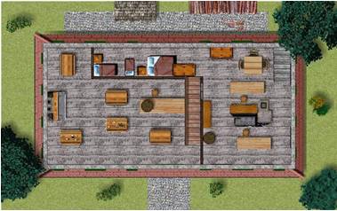
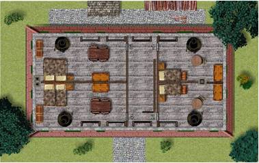
Chapter 4 deals
with the raster mapping of floor plans and dungeons in multi-layer
technique. This chapter devotes
special attention to the mapping of a dungeon or floor plan in such a manner
that the game master easily can show his or her players all things that their
PCs can see and hide all things that they haven't seen yet. The project in this chapter is the mapping
of the Old Well Inn that once stood
in the Northern Bavarian city of Bamberg.
The building has a cellar, a ground floor and an upper story. |
|
|
|
|
|
|
|
In Chapter 5 one
begins to see how to get the power of all of FM8's horses into a map. The
RPG world has a thing with raster maps.
It's said that if everything in a raster map is scaled fine, it looks
like a mish mash on strong zoom-outs.
On the other hand, one claims, if things are scaled right for a wide
scale raster map, most objects pixilate terribly on close zoom-ins. With a number of
graphic programs that's quite true. FM8 is one of relatively few programs
used to make RPG maps where this doesn't need to be the case at all. FM8
has zoom controls that can and should make such problems superfluous in your
map. When you use FM8 well, important objects in your maps will have different
scales at different zoom levels.
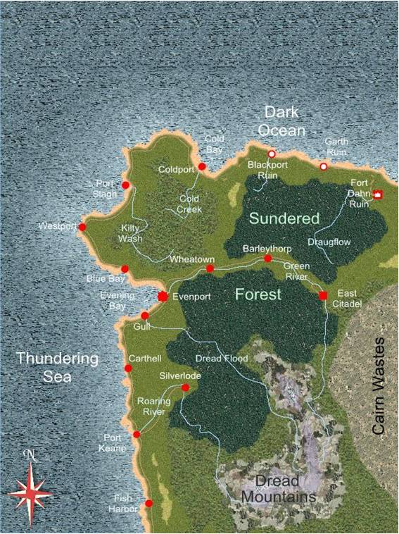
Chapter 5 shows how that works. But there's more
yet. There are many game masters and cartographers
who would like to have maps so versatile that one could zoom in on any
settlement on the map, and instead of seeing the isometric or cartographic
symbol that had been there, one would see a totally zoomable, detailed map of
the settlement. Chapter 5 takes a
large scale overland map with scale dimensions of 3,900 by 2,800 miles. The region mapped includes the town of
Odínsdomov, which was mapped in detail in Chapter 3. When one zooms in on Odínsdomov in the
overland map, one sees the town map, completely zoomable down to the
individual wood piles and outhouses.
How that works also is a topic of Chapter 5. Chapter 6 takes on
another important theme for raster mappers:
The making of presets is important knowledge for any serious
mapper. Presets make it possible for a
raster cartographer to fill large areas quickly with credible symbols in full
quality and with full zoom abilities. Chapter 7 shows how
to use FM8 to make raster
symbols. The topic in this section is
the Eyerlohe hunting castle in Northern Bavaria, which is modeled into an FM8 raster symbol in FM8 without the help of any outside
program. |
|
|
|
|
|
For all of FM8's power, there are some things it
can't do. One of them is to create
symbols with transparent elements. FM8 can't do that, but it's an easy
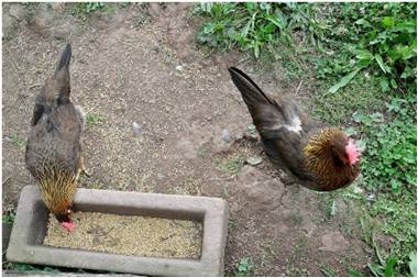
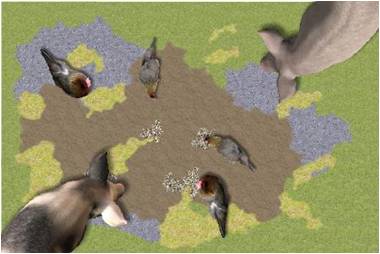
chore with a free graphic program like Paint.NET. Chapter 8 starts out with a digital photo
of two chickens that supposedly are of a race bred already in the 1400s and
1500s - two medieval chickens, if you will. This chapter shows
one how to pull the chickens separately out of the photo with Paint.NET and turn them into two FM8 symbols with transparency. Once the symbols have been created, the
digital medieval chickens can join the pigs in the barnyard, as seen to the
right above. |
Five files are available for
download. All are in the same download
folder:
1. pdftu01.zip is a necessary file. It contains the tutorial PDF booklet (40 MB).
2. tu01sptpack01.zip also is a necessary file, It contains all the support files necessary
to do the exercises in
the booklet. Be sure to read the small PDF file in this zip!
It contains important information
(47 MB).
The three remaining files are
optional. They contain finished versions
of the three main maps made in the tutorial
exercises:
·
overland.zip, from Chapter 2 (24
MB)
·
odinsdomov.zip from Chapter 3 (60
MB)
·
oldwellinn.zip from Chapter 4
(16 MB)
Vintyri Download Site
·
Click here to download the tutorial PDF booklet (78 MB).
·
Click here to download the support files pack (47 MB).
Optional files:
·
Click here to download the overland map (Chapter 2 - 24 MB).
·
Click here to download the town map (Chapter 3 - 60 MB).
·
Click here to download the inn floor plan (Chapter 4 - 16 MB).
Alternative NBOS
Download Site (www.nbos.com)
·
Click here to download the tutorial PDF booklet (78 MB).
·
Click here to download the support files pack (47 MB).
Optional files:
·
Click here to download the overland map (Chapter 2 - 24 MB).
·
Click here to download the town map (Chapter 3 - 60 MB).
·
Click here to download the inn floor plan (Chapter 4 - 16 MB).
Click here for the alternate MediaFire download site!
REMEMBER when you load these three maps or
the Fallen Lands map in the support
pack to immediately
click the menu option Map in FM8 and then the option Display
Quality. Set the basic Display Quality to Highest
and then pick Special Effects - Medium Res. Without these settings, the maps will not
always work
in the manner described
in the tutorial!